When Jonathan Harris and Ben Miller met more than a decade ago while flying remote control planes at a local field, never did they think that their mutual hobby would turn into a business relationship. But today, Harris, the director of airborne mapping at engineering firm Olsson Associates, and Miller, a sales engineer at drone manufacturer Draganfly Innovations, are now partnering up on some sophisticated surveillance work.
Olsson, specializing in environmental resources and compliance, water and wastewater utility design, transportation, power generation, building systems and urban planning, is using the Draganfly drones for aerial photography and videography to supplement the mapping the company does for large-scale projects using Cessna planes.
Harris brought in two Draganflyer X4-ES portable drones to survey land, the main goal being to increase productivity. “It takes two people and two days to survey 10 acres of ground, but we can cover the same area and get the same quality with a drone in a few hours,” he says.
Though we might think of drones as the perfect holiday gift for a child, industrial drones—also called unmanned aerial vehicles (UAVs), unmanned aircraft systems (UASs) and remotely piloted aircraft—are important tools in military, public safety and agriculture applications. And now they are soaring into the commercial space, being used in manufacturing applications such as flare stack inspection in oil and gas, or as a safe way to get a visual on power lines or the roof of an industrial plant, for example.
Using drones in business is, well, taking off.
According to the U.S. Federal Aviation Administration (FAA), sales of UASs for commercial purposes are expected to grow from 600,000 in 2016 to 2.7 million by 2020. That’s a lot of UFOs (unmanned flying objects) in the airspace. But when the skies get crowded, the FAA gets circumspect with its rules, clamping down with strict policies. That’s why the FAA is the biggest obstacle to industrial drone adoption today—specifically, the agency’s requirement that operators be licensed pilots.
By law, any aircraft operation in the national airspace requires a certified and registered aircraft, a licensed pilot and operational approval. Section 333 of the FAA Modernization and Reform Act (FMRA) of 2012 grants the secretary of transportation the authority to determine whether an airworthiness certificate is required for a UAS to operate safely in the National Airspace System (NAS).
But under a new proposed law, Part 107, operators will not be required to have pilots’ licenses for small unmanned aircraft systems. Instead, this “license to fly” allows an operator over 17 years old to obtain certification by taking an in-person knowledge test and submitting to a Transportation Security Administration (TSA) background check. But flights will be restricted to daylight within visual line-of-sight of the operator and cannot be flown over people.
This will alleviate the biggest obstacle in drone adoption, but there is a safety element associated with proper training that is extremely important.
“A lot of people ask why you have to be a pilot to fly drones, and I agree, it’s a high barrier to entry,” Harris says. “But the understanding I have of airspace regulations, communications protocols and general flight dynamics have really helped when I apply them to the UAV space.”
Still, the passing of Part 107 will allow Olsson Associates to expand its services as clients ask for more and more capabilities, such as thermal and infrared imaging from the air or oblique images from different angles. When the FAA lightens up on the pilot license, “we’ll have a drone and an operator in every office,” Harris says.
Automation in the air
Drones are, at their core, data collectors, which perhaps count these robotic flying objects among the many machines that make up the Internet of Things (IoT). The multi-rotor systems come with an onboard computer, multiple sensors, GPS positioning, accelerometers and high-definition cameras.
Many drone manufacturers, including Draganfly, have developed vehicle management software and connect with mapping and data modeling applications. Draganfly, founded by Zenon Dragan, originally set out to build a fun remote control flying saucer product, but the company is now focused on small UASs for commercial use that are designed from the ground up to be safe and solid systems.
The company’s most current system is the Draganflyer Commander, which comes with an 80 percent stronger folding airframe, more powerful motors, and longer fly time (about 40 minutes vs. 20 minutes) as a result of two onboard batteries. Aside from longer flight endurance, the dual battery acts as a safety backup. “If there is a battery failure, the system doesn’t fall out of the sky,” Miller says. If that happens, it knows to come home to figure out what’s going on.
An emerging alternative to battery power is the use of hydrogen fuel cells to power drones. A company called Intelligent Energy showed off a prototype of its fuel cell range extender at the Consumer Electronics Show (CES) in January. Shortly thereafter, the company announced it had signed a letter of intent with a major drone manufacturer to develop hydrogen fuel cells for its products.
“The first advantage is to increase flight time,” says Julian Hughes, Intelligent Energy’s group business development director, who declined to name the drone manufacturer his company has partnered with. “But the second is that it allows bigger payloads on a drone.”
Commercialization of the fuel-cell powered drone takes one to two years, Hughes says. Initially, it may mean a higher price tag, but companies will pay a premium for increased flight time.
So how much does a drone cost? It depends. If you are getting a do-it-yourself “Franken-copter,” as Draganfly’s Miller calls them, you’ll be out anywhere from a few hundred to a few thousand dollars. But these systems can malfunction and crash, potentially hurting someone. Draganfly drones range in price from $9,000 to $37,000, and are built to survive—and not fall out of the sky.
Draganfly was recently acquired by Trace Live Network, which makes visual intelligence tracking technology that autonomously operates devices and feeds live streams of footage directly to the Internet. The computer vision technology enables users to take advantage of real-time video streaming and photos that can be uploaded to the cloud. In addition, while Draganfly has developed the drone platform and operating environment, the Trace technology will provide a software development kit (SDK) so that people can create their own applications.
“We are making sure we are facilitating positive, productive use of the data,” Miller says. “Big deal if you can collect the data, but then you can’t do anything with it.”
Drones as a service
Having the ability to pull data collected by drones into other programs is creating a new buzz as it relates to Big Data.
“It’s now kind of a gold rush as to how to analyze images,” says Benjamin Benharrosh, co-founder and director of sales and marketing at Delair-Tech, a company based in France that recently expanded operations to Australia and the U.S.
Delair-Tech has the first UAV certified for “beyond visual line of sight” operations, opening up an opportunity for long-range drones. The company also incorporated automated algorithms into the drone-acquired data to process workflows and store in the cloud, using a web interface to obtain actionable real-time data. For example, anomaly detection algorithms and pattern recognition software can leverage the database to identify unauthorized construction, pipeline leaks, or even detect crop health in precision farming applications.
Bentley Systems is another company coupling drones with sophisticated software. It’s using drones in manufacturing environments to gain a better view of assets for architecting and engineering infrastructure. In the past, measuring out a production line to see if new equipment would fit, for example, required 3D laser scanner technology to create a point cloud for coordinating space. But scanners can be expensive and difficult to operate. Bentley has a better way, using its ContextCapture reality modeling software that turns photos taken by a drone or smartphone into geo-referenced 3D models that include precise context for design, construction and operations decisions.
Similarly, last May, drone manufacturer 3DR launched Solo, which can automatically control both the copter and the camera positioning in flight. While it provides multi-axis cinematic live HD video that any moviemaker would love to have, the addition of Site Scan, an aerial analytics platform released in March, makes the Solo smart drone useful as an industrial inspection tool, too.
Site Scan leverages image capture from Sony and cloud processing from Autodesk to deliver end-to-end workflows. The app supports three modes: inspect, survey and scan. The workflow—from flight and collection to processing and importing data—is managed entirely on a Sony tablet. And, as part of the Autodesk Forge platform, Solo is a complete drone-to-cloud service.
“It’s software as a service, but instead of humans entering data on screens, drones are entering data automatically while flying,” says Keith Bigelow, vice president of the enterprise division at 3DR.
The tablet-based flight tool app is intuitive, offering three icons to represent the three modes of operation. An operator can even download the flight path with GPS coordinates. There are no intimidating sticks or levers, rather, it is something that looks like an enterprise tool, Bigelow says. “I can take my finger and circle the building that I want a map of and the drone will take off and fly while I sip my coffee.”
Customers can fly with confidence by defining geo-fences the drone is not to cross by simply drawing it on the screen. Site Scan also includes airspace safety information software, which alerts users if they’re about to fly in restricted airspace.
The Solo drone with Site Scan is purchased at a price of $4,999 equipped with a Sony camera or $3,249 with a GoPro camera. A monthly service fee of $499 covers storage of data in the 3DR cloud. The information is also encrypted so that it is secure.
Cybersecurity and swarming
The future of drones is bright, but there are other obstacles aside from FAA regulations—specifically, security breaches. There really isn’t any reason a drone couldn’t be hacked, which is why industrial drone vendors are incorporating encryption and password protection as part of the data transfer.
3DR is also able to update drones in the air—just like a cellphone—with upgrades to the operating system and software delivered while in flight to always keep it up to date.
Security is indeed a concern for all end users. “UAV operators have to always be one step ahead of people with malicious intent,” Olsson Associates’ Harris says. Especially as more drones populate the sky.
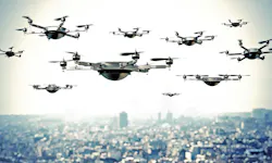
Which begs the question: Can companies network multiple drones in the sky?
“That’s illegal,” notes 3DR’s Bigelow. “The software exists to fly a swarm, but the regulatory environment does not.”
However, he says swarming can be a valuable way to scan hundreds of acres at once or for use in large-scale mines. Drones could even be controlled to fly in a line or circle to see something from a variety of viewpoints in real time. But until the FAA gives the green light, 3DR’s drones will be flying “solo.”